Some residents of properties perched along Newsome Creek, which runs through Sorrento on its way to Shuswap Lake, feel as though they are teetering on the edge.
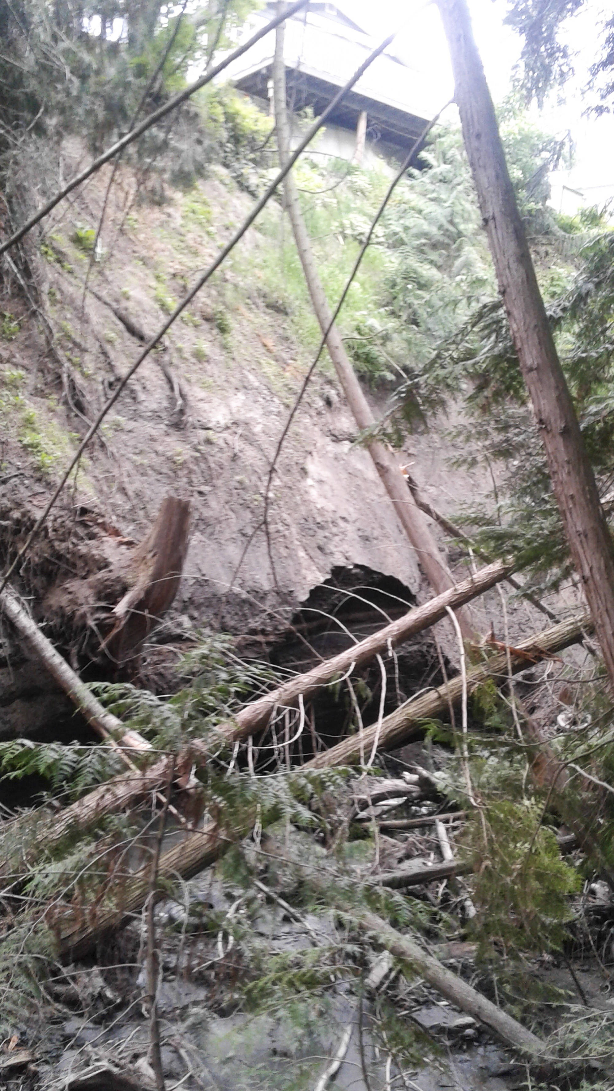
The homes on Caen Road sit on the edge of a deep ravine with the creek running along the bottom. Nearby residents say the creek was no cause for concern until its course changed during the violent spring freshets of 2017 and 2018. Now, the creek’s banks are eroding in a way that is undercutting people’s properties and putting homes at risk.
Among those at risk is Jocelyne Gilbert’s home where she runs a home-based barber shop. Gilbert took photos of the walls of the ravine behind her home in May, June, August and September 2018; they show a continuing pattern of erosion and slope failure along the path of the creek north of the Trans-Canada Highway.
Related:Salmon River upgraded to flood warning status
“They need to get someone in here with some heavy machinery to dig a new channel and remove the dead fall,” said Tim Lukashuk, whose 93-year-old mother Anna Whillans lives next door to Gilbert.
The danger to the homes on Caen Road is well illustrated in an engineer’s report dated Oct. 6, 2018. The report created by Westrek Geotechnical Services was based on monitoring erosion in the Newsome Creek gully throughout the spring of 2018.
According to the report, the risk to Gilbert’s residence at 2809 Caen Rd. is high. It recommends the owner either stabilize the slope or move the residence to the front of the property. Gilbert says she has been told that stabilizing the slope from below is now unsafe and moving the house forward is not feasible due to road setbacks.
The risk of a building being damaged or condemned due to the slope slipping away is not confined to Gilbert’s property. The report states that the woodworking shop located at the rear of 2819 Caen Rd., the pottery shop at 2821 and a three-car garage at 2823 are all at high risk due to instability of the gully walls.
It states Whillan’s house at 2807 Caen Rd. and the garage at 2827 Caen Rd. are also at an elevated risk, which may increase if the creek continues to erode the gully walls.
Related:Landslide destroys homes but spares occupants
Paul Demenok, the Columbia Shuswap Regional District (CSRD) Electoral Area C Director, has been lobbying higher levels of government, hoping to get help for the residents of the Caen Road properties.
Demenok sent a letter to Doug Donaldson, Minister of Forests, Lands, Natural Resource Operations and Rural Development, in early May this year following the erosion of the bank caused by the 2017 freshet. In the letter, Demenok appeals to Donaldson for an immediate plan of action developed by engineers that would manage the creek’s flow, repair damage done and mitigate future risks.
Demenok received a reply in early June from Gerry MacDougall, a regional executive director with the ministry.
“The responsibilities of local authorities as first responders in an emergency situation are outlined in the Emergency Program Act.
“The province supports local authorities in preparing for, responding to and recovering from emergency incidents and events. The situation at Newsome Creek is unfortunate and the province has had ministry staff attend the site to offer expertise, and Emergency Management BC (EMBC) had approved funding for the evacuation of the properties earlier this month,” the response letter reads.
Eleven properties on Caen Road were the subject of an evacuation alert from May 3 to Oct. 24 this year.
Related:UPDATE: Theory emerges on landslide cause
MacDougall’s letter suggests the CSRD apply for funding through the National Disaster Mitigation Program administered by EMBC or the Community Emergency Preparedness Fund administered by the Union of BC Municipalities.
Derek Sutherland, the CSRD’s protective services team leader, said the regional district is seeking funds from EMBC to conduct a feasibility study which would look at measures to prevent further damage and what they will cost. He said he hasn’t heard back from EMBC on the request yet.
He added the feasibility study is the next step in determining what kind of work is possible in the Newsome Creek area. While EMBC generally only funds emergency response work, Sutherland said in light of the significant chance of future property damage out there, he hopes they provide preventive funds in this case.
The engineer’s report on the erosion near Newsome Creek was funded by EMBC.
“We think the province is definitely responsible because that creek bed and that stream belong to them, the water itself belongs to them, so if the water is causing the damage, how can it be a CSRD responsibility,” Demenok said.
“It’s a jurisdictional battle. Everyone is in their silos and has their little bit of responsibility and authority but no one is getting together on this.
We have to sort of cut through this bureaucracy to get something done and help save these people’s homes.”
The affected properties are downstream of the Trans-Canada Highway which the creek passes under through a culvert which Demenok says is undersized.
“When that water comes through it’s just an absolute torrent,” he said.
A statement from the Ministry of Transportation and Infrastructure said work to repair roads damaged by Newsome Creek during the spring melt upstream of the highway was prioritized. A hydrological assessment of the creek was undertaken and as a result culvert size upgrades, including at the Highway 1 crossing, are being considered.
“Additional engineering is required before we can confirm the culvert sizes and when these repairs may take place. These repairs will likely take place sometime in the new year,” the statement reads.
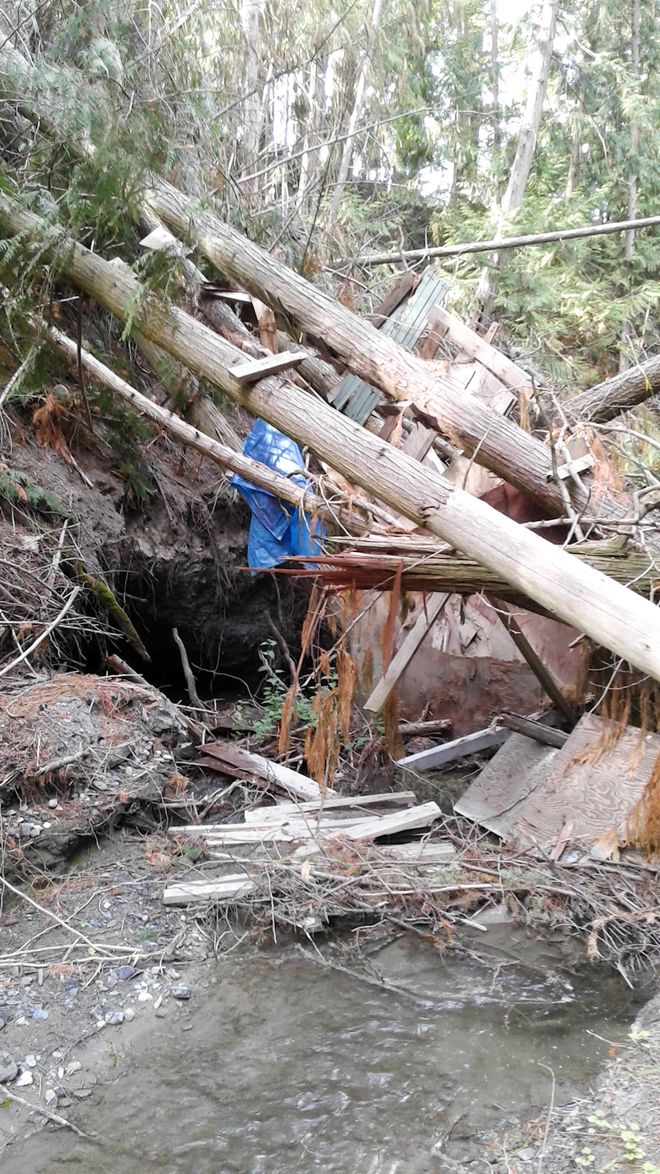
Along with eroding banks, unstable trees pose a danger to homes on Caen Road.
A few metres down the creek from Gilbert’s house, two trees with a treehouse suspended between them have fallen into the ravine. She says the fallen trees have split the creek flow, further eroding the bank on each side.
A total of 47 dangerous trees were identified as dangerous to lives or property in the Newsome Creek area by a report dated Oct. 9 this year. It is based on assessments of trees within the gully performed on June 22 and 27.
Residents of the area around the creek are organizing a letter-writing campaign to all levels of government and asking for an appearance before the CSRD board in hopes they receive some help before it’s too late.
@SalmonArm
jim.elliot@saobserver.net
Like us on Facebook and follow us on Twitter