British Columbia’s desperate battle against hundreds of wildfires continues on multiple fronts Sunday, but no new evacuation orders have been added overnight to the thousands already in place across the province.
B.C. Premier David Eby said Saturday the situation was “grim” as he announced an emergency travel ban to fire zones to free up accommodation for 30,000 or more evacuees across the province, as well as fire crews.
The last new evacuation order was issued at 1:33 p.m. Saturday for residents of the tiny lakeside community of Sorrento on Highway 1, due to the Lower East Adams Lake fire complex which has caused extensive regional destruction in the Columbia Shuswap in the southern Interior.
In the central Okanagan to the south, ground zero for a massive fight against blazes on both sides of Lake Okanagan, no new orders have been issued since 9:18 p.m. Friday.
Hundreds of firefighters there are engaged against fires that have been looming over Kelowna and West Kelowna, causing significant destruction of homes.
Most of the province’s evacuees are from the central Okanagan.
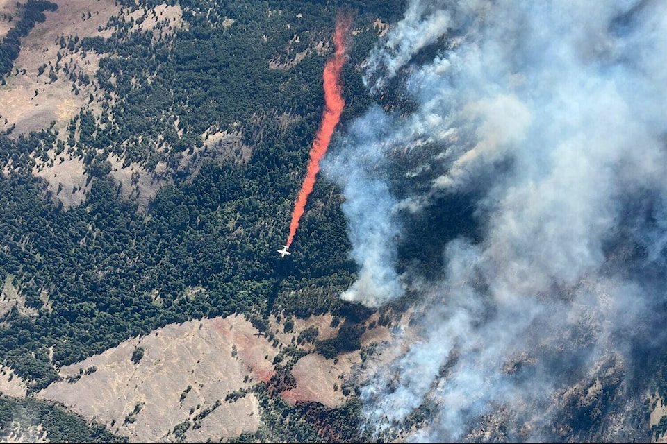
There are 386 active wildfires burning in the province, including 14 that are either highly visible or threatening public safety. There have been 14 new fires in the last 24 hours.
Grouse Complex – West Kelowna, Kelowna
Grouse Complex includes the McDougall Creek wildfire in West Kelowna, Walroy Lake wildfire in Glenmore and Clarke Creek wildfire in Lake Country.
Size and location: 11,943 hectares in total
State and cause: Considered out of control, and cause under investigation
Current evacuations: An estimated 5,053 properties are on evacuation alert in Kelowna, while 2,057 have been ordered evacuated.
BC Wildfire Service and West Kelowna Fire Department said overnight response was largely fire-front following tactics in neighbourhood and interface areas as it moved down towards homes.
Fire activity this morning is rank 2 and rank 3, which is a downgrade from yesterday’s rank 4 and 5. On Sunday, crews will be setting up structure protection equipment in priority areas and extinguishing active fire near homes. Given how dynamic the incident continues to be, BC Wildfire and structure protection personnel are highly mobile and able to reposition to support response and defense tactics based on fire activity.
Line locators will be working to determine locations for heavy equipment to begin constructing heavy equipment machine guard.
The BC Wildfire Service continues to respond to the McDougall Creek wildfire (K52767) adjacent to West Kelowna, the Walroy Lake wildfire (K52808) adjacent to Glenmore and the Clarke Creek wildfire (K42815) on the west side of Lake Country. pic.twitter.com/AXstbWCpsT
— BC Wildfire Service (@BCGovFireInfo) August 20, 2023
Crater Creek – Keremeos
Size: 37,000 hectares, started 19 km southwest of Keremeos
State and cause: Considered out of control, caused by lightning
Current evacuations/updates: On Saturday, the Regional District of Okanagan-Similkameen has downgraded an evacuation order to an alert for some properties along the Similkameen River, specifically the west side of Highway 3 includes Suncatchers RV Park, Riverside MH Park and Lucky R MH Park.
The district says 13 properties remain under an evacuation order and 195 are under an alert as a result of the Crater Creek Wildfire.
As of Sunday, the fire had crossed over the Canada-U.S. border. Overnight, crews were doing constant patrols across the fire edge from the red bridge to Paul’s Creek to monitor fire behavior and any potential issues.
B.C. Wildfire Service says the north and east flanks saw minimul growth and has burnt into a previous burn from 2018. Meanwhile, the south flank of the fire has been the most active area, influenced by north winds and is expected to experience some growth.
READ MORE: Community leaders urge calm and patience as crews battle Okanagan wildfires
Brush Creek East – Chase/Sorrento
The Lower East Adams Lake and the Bush Creek East wildfires have merged and will be referred to as the Bush Creek East fire going forward.
Size: 41,000 hectares
State and cause: Out of control, caused by lightning
Current evacuations/updates: Visibility remained an issue for those on the frontlines Saturday. So much so that crews were unable to get in the sky due to there being only a .5-mile visibility, as BC Wildfire Service adhered to a the 1-mile visibility standard specified in the Canadian Aviation Regulation.
READ MORE: BC Wildfire provides update to Bush Creek East blaze in Shuswap
ALSO READ: Evacuation order issued for Sorrento/Skimikin areas in the Shuswap
There are several hazards present in areas that the fire has passed through including danger trees and non-vegetative smoke, the wildfire service said.
“Wildland firefighters do not have the training or personal protective equipment to work safely around these hazards.”
Structure protection crews spent Saturday mopping up around structures, meanwhile, wildland firefighting crews were focused on slowing fire growth toward structures in areas where the fire progressed actively through timber and grassland.
Kookipi Creek – Boston Bar
Size: 10,500 hectares, south of Lytton
State and cause: Out of control, caused by lightning
Current evacuations/updates: Evacuation orders continue to be in effect within the Fraser Valley Regional District, Thompson-Nicola Regional District, Lytton First Nation and Kanaka Bar Indian Band.
Highway 1 remains closed between Lytton and Hope since Thursday. An update is expected Sunday morning.
#BCWildfire Service continues to action Kookipi Creek wildfire (V11337) originally located approximately 16 km northwest of Boston Bar and seven km east of Nahatlatch Lake. It’s currently 8,791 ha in size. pic.twitter.com/728Nk3G9Kp
— BC Wildfire Service (@BCGovFireInfo) August 18, 2023