Heat, cold, rain – three simple words that have an enormous effect on whether the Shuswap will be subject to more flooding.
Water levels are already high, as are some upper-level snowpacks.
The recent heat wave spurred snow melt at upper elevations where snow accumulation actually increased throughout March, April and May, thanks to two-to-three times the normal amount of precipitation, says David Campbell, head of the Ministry of Forests, Lands and Natural Resource Operations’ River Forecast Centre.
Campbell says the Park Mountain snow pillow that feeds Shuswap River is above historic levels at about 150 per cent of normal for this time of year.
Two new stations above Enderby and at Silver Star have high readings with only about 10 to 20 per cent of the snow melted so far.
The snow pillow above Celista is also nearing historic levels with two-thirds to three-quarters of the snow yet to melt.
Water levels in the Salmon River and its contributing tributaries have dropped somewhat as the mid-level melt is pretty much over, Campbell says. But the river remains under a flood watch as a substantial rain could push the level up again.
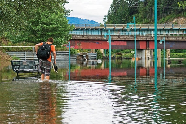
He says the weather will also be a big factor in what happens on the Shuswap River and in Shuswap Lake where levels are already high and possibly heading to 2012 levels, the year Sicamous experienced massive flooding.
Sicamous resident Bernhard Kramer has maintained shuswaplakewatch.com for more than 20 years, providing data on the day-to-day change in water levels.
“I just noticed lake levels but couldn’t figure out why it is so extreme, so I started doing measurements – more for fun,” Kramer says, pointing out he has noticed changes over the past couple of years. “Runoff is early and the transition from winter into spring is different than it was before, the timing has shifted. Last year we were three to three-and-a-half weeks earlier with the runoff. This year it’s almost four weeks earlier than normal.”
Kramer, who measures the water levels by the Sicamous bridge every day between 6 and 7 p.m., said Tuesday the level had risen by 9 to 10 centimetres each day.
“So there is a lot of water in the creeks and rivers, and a storm a few weeks ago brought up the level 22 centimetres in one day,” he says. “That was what caused the problem in 2012; the lake was high up and then came the rain.”
“The lake was already at peak level, not very high, there was not much snow in the mountains that year so I didn’t expect any problems,” Kramer says. “But two big weather events pushed the levels up over the top. We’re not yet at flood level this year, but it’s slowly getting there.”
And that takes us back to what Mother Nature doles out.
Environment Canada meteorologist Alyssa Charbonneau said Tuesday that the strong ridge of high pressure that brought sunny skies to the Shuswap was not unusual, but the heat it contained is above normal for this time of year.
“We are now going to transition into unsettled weather thanks to a cold low sitting off the coast that could bring showers and thunderstorms, which is not uncommon,” Charbonneau said, noting the long, cold and wet spring was definitely out of character and is likely what made the past several days of hot weather seem exceptional.
“Even though it got quite hot, it didn’t break any records,” Charbonneau says, pointing out that unlike last Tuesday’s wild windstorm, the transition to a low-pressure system will not be as strong. “We are going to see cooler temperatures, but just back to seasonal normal.”