Keep the gum boots and umbrellas handy.
While the tail end of one system segued into a ridge of high pressure, bringing gradual drying and temperatures into the high 20s to 30s, another system is expected to bring more rain by the weekend.
“It’s the season to be thinking about severe weather,” says Doug Lundquist, warning preparedness meteorologist with Environment Canada, who notes the advancing cold-air system could arrive with severe thunderstorms. “June is normally wet; I call it the monsoonal month, but this one is on steroids.”
Between June 1 and 16, the weather station at Salmon Arm Airport measured 80 mm of rain, considerably higher than normal rainfall, which is 63 mm for the entire month.
Heavy rain and rapid snowmelt at upper levels has swollen rivers and resulted in the BC River Forecast Centre issuing a flood warning for the Shuswap River downstream near Enderby, and a flood watch for Shuswap Lake and tributaries, including Eagle River.
A flood watch means river levels are rising and will approach or may exceed bankfull, and a flood warning means river levels have exceeded bankfull or will exceed bankfull imminently.
The station at Salmon Arm recorded a lake level of 348.76 metres and rising seven to eight centimetres per day. “Shuswap Lake is expected to continue rising through the next week and peak at approximately 20-year levels,” reads the advisory.
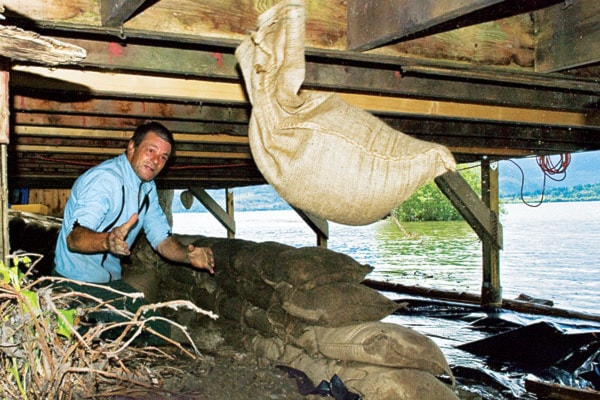
By Tuesday morning, the lake level was 349.1 metres – up 10 cm overnight, and City of Salmon Arm public works staff were busy implementing the city’s action plan.
“We’re actively starting to protect infrastructure. We’ve contacted Federated Co-op and asked them to place a log boom at the end of marine wharf and are adjusting gangways, monitoring lake levels daily and preparing to sandbag the Canoe Beach pump station.
“There has been an erosion of the land by wave action and the boat launch dock is now four feet away from the land,” says Rosenberg. “The federal wharf is still accessible, but the parking lot is under water, and in another four inches it will be so deep you’ll need to wear your bathing suit.”
Rosenberg adds that the notion of closing Canoe Beach is becoming more realistic. The CPR pedestrian tunnel is on the verge of being closed and a storm system that empties into the lake is close to surcharging, because it can’t manage the load.
“Our concern now is definitely on lake levels,” says Rosenberg pointing out that other rivers are coping with the load. “In terms of boaters, not creating wakes can make all the difference in the world for some property owners that are in peril. And wind is not our friend right now.”
The Shuswap Emergency Program of the Columbia Shuswap Regional District advises the province has made sandbags and sand available at government expense to those affected by flooding.
These are available at City of Salmon Arm public works yard, District of Sicamous public works yard, Swansea Point’s Oxford Road Beach Access Point, Sorrento Parts and Service, Gem Gravel in Celista and Falkland Fairgrounds beside Bolean Creek Bridge.
In Seymour Arm, residents in need of sandbags and sand should contact the Seymour Arm Community Association.
“Parents are encouraged to keep children and pets away from watercourses at this time,” cautions the June 18 SEP release.
“Banks will be slippery and potentially unstable due to the erosive qualities of fast-flowing water.”
For flood risk info and preparedness tips, visit http://www.pep.bc.ca/floods/index.html.
To report a serious flood situation that may endanger life safety or necessitate an emergency evacuation, call Emergency Management BC at 1-800-663-3456.
And enjoy the few days of respite because the next system is scheduled to arrive from the south on Saturday.
“I don’t like it when I see it straight out of the south, it definitely raises flags,” says Lundquist, pointing out the next system is moving in off the coast of California and is expected to roll on up through Oregon and Washington. “We don’t have the protection of the mountains and the alleyway stops in the Shuswap because of the mountains to the north.”
Looking down the road to a hopefully sunnier future, Lundquist says the monsoonal pattern should give way to drier weather patterns within the next few weeks – sometime between July 1 and 10.